I certainly didn’t set out to circumnavigate the city of Piedmont last Saturday, or to walk a half marathon through Oakland’s hilly northeast quadrant. One thing leads to another, however; that’s just the way life works—or my life, at least. You put one foot in front of the other, and then you do it again—a step, and another step, and then another, and the next thing you know, you’re aimlessly wandering the streets of Oakland, California.
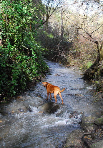
My walk began routinely enough: I thought I’d take advantage of a break in the rains to walk the dog up to beloved Sausal Creek, hoping to see it in full flow after all the storms last week. It was somewhat anticlimactic—even my dog, who doesn’t take naturally to water, was unfazed by the current and waded right in.
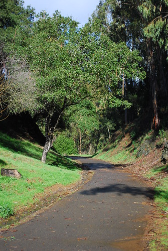
The clear weather was holding, and I wasn’t in the mood to turn heel and walk back down the hill yet, so I decided to check out the walking and biking trail that leads from Montclair Village up into Shepherd Canyon. It’s a bit surprising that I’ve never been there before, since I walk up to Montclair occasionally, and have even trekked from my apartment up to Redwood Regional Park at the top of the hill a couple of times. I’m glad I finally took a look. The trail was laid where Sacramento Northern tracks used to run, so it curves nicely—and not too steeply—about a mile into the Canyon before ending at a cul de sac off Shepherd Canyon road, near where the train used to enter a tunnel through the hills.
A few panels posted alongside the trail have some interesting history about the railroad and the canyon, including the astonishing fact that CalTrans proposed building a highway up Shepherd Canyon to the east side of the hills. Thankfully, there was enough opposition that the idea never became reality. Oakland is already so criss-crossed with freeways that it’s frightening to imagine that if CalTrans had really gotten what it wanted, then we would have even more. The state legislature permanently protected the canyon from freeway development in 1972, and a few years later the city council set aside land for parks and trails, bequeathing us the Shepherd Canyon that we know today. (You can read the informational panels in pdf form thanks to the Shepherd Canyon Homeowners Association.)
The trail is a pleasant enough place to take a walk, but with truly glorious parks like Joaquin Miller and Redwood and Sibley just up the street, I’d be surprised if it’s used very much for recreation except by people who happen to live in the neighborhood. So it was heartening to see how well-used the trail is for quotidian, utilitarian purposes. In my half hour walking up the trail and back, I passed at least a dozen people who were clearly walking home from the grocery store, or biking home from errands, or walking down to Montclair Village to go to a coffee shop or the bank or wherever. That’s more people than I sometimes see walking around in my own denser, more walkable neighborhood! Since there are no sidewalks on most residential streets in Montclair, and the curvy and steep roads can make for tiring, long, and dangerous walking, I doubt that most of those people I saw would have been walking to and from Montclair Village if they didn’t have the trail. (There are some public stairways around Montclair which serve much the same function.)
After I got back to Montclair Village, I basically had two options: either retrace my steps back down Park Boulevard to home, or make some kind of loop. Park Boulevard is plenty interesting, at least to me, but I always prefer loops, so I headed north on Mountain Boulevard toward Lake Temescal, where two optimistic little girls were using the fleeting sunshine as an excuse for pretending that summer was already here.

I was about nine miles into the walk by then, and beginning to wonder why I had walked to a point in Oakland which happens to have no direct route back to my apartment. Spontaneous rambling is fun and all, but the benefits of planning ahead were starting to sink in. No matter—I still had plenty of fuel in the proverbial tank, and IÂ had planned ahead enough to bring some snacks for the dog and some water for both of us, so onward we went, first down to Rockridge, then down Broadway to MacArthur, and then finally to home.

It seems like I end up taking a long walk like this once or twice a year, when I have a free afternoon and a hankering to see some streets that I haven’t seen before. Â Not only is walking the best way, hands down, to get to know a neighborhood, but it also clarifies the relationships between neighborhoods, both geographically and sociologically. The architecture changes, the years and models of the cars parked in driveways change, sidewalks disappear or reappear, or a freeway blocks ones path and forces a quarter-mile detour. Strangers on the street greet you cheerfully, or eye you warily, or flaunt their indifference. Front yards have barking dogs behind chain link fences, or obsessively manicured landscaping, or kids’ bikes left on the grass next to driveways. All these things determine the character of a place.
I wrote a post in June about how great it is to get around town by bicycle, but for me, riding a bike is really a sort of compromise, between the speed and distance possible in a car and the benefits to one’s health and one’s soul that walking brings. As far as I’m concerned, the ultimate in human transportation is not anything designed by Bianchi or BMW or Boeing, but rather a technology devised by evolution, nature’s master engineer. You put one foot in front of the other, and then you do it again—a step, and another step, and then another, and the next thing you know, you’re not so worried about where exactly you’re going.


14 Comments